Highlights from recent WSGS research and publications
It has been a busy summer and early fall at the WSGS. Our scientists have been in the field across the state, collecting new data, conducting geologic mapping, and working closely with federal and industry partners to advance understanding of Wyoming’s geology and resources. In addition to fieldwork, we released several major publications and datasets that modernize our geoscience records and expand access to high-quality public data..
Airborne Geophysics
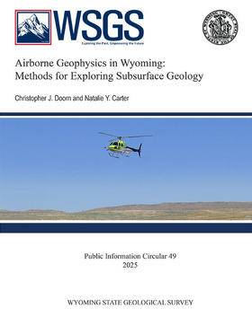
We published Public Information Circular 49, Airborne Geophysics in Wyoming: Methods for Exploring Subsurface Geology, which highlights recent and ongoing airborne magnetic, radiometric, and electromagnetic surveys. These surveys are flown with specialized instruments mounted in aircraft, allowing geologists to map variations in the earth’s magnetic field and natural radioactivity. Such data are essential for identifying critical mineral deposits, evaluating groundwater systems, and understanding Wyoming’s deep geologic framework. With the completion of recent surveys, nearly 20 percent of the state will be covered by Rank 1 geophysical data—the highest standard—representing a significant step toward building one of the most comprehensive airborne geophysical datasets in the region. This effort is the result of collaboration between the WSGS, the U.S. Geological Survey, and industry partners, and the results are already being used in exploration programs.
This circular is available for free download from the Wyoming State Geological Survey website. The published geophysical data discussed in this publication can be downloaded from the U.S. Geological Survey’s website (South Pass–Granite Mountains, Medicine Bow Mountains, Sierra Madre-Elkhead Mountains-Medicine Bow Mountains).
|
Digital Precambrian Surfaces
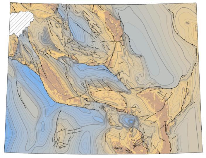
We also released new digital surfaces that model the structure and depth of Wyoming’s Precambrian rocks—the oldest rocks in the state, and the foundation for every basin and mountain range that sits above them. These surfaces were developed by integrating seismic interpretations, well data, elevation models, and historic mapping into a unified 3D framework. The result is a tool that helps geologists better define basin boundaries and assess the potential for energy and mineral resources. Available in formats compatible with ArcGIS Pro and other GIS platforms, these data can be easily incorporated into exploration workflows. The release includes both a depth-to-Precambrian map and a structure map, along with the supporting geodatabase containing contours, faults, and outcrops. The dataset is available for download here.
A map showing the elevation, relative to sea level, of the Precambrian rocks in Wyoming.
Uranium Resources Database
The WSGS completed one of its largest digital preservation projects to date with the release of the Wyoming Uranium Resources Database. This comprehensive dataset consolidates information from decades of exploration and mining into a searchable, GIS-based platform. It replaces the widely used Uranium Map of Wyoming (2010) and adds new functionality, including attributes for mines, in-situ recovery operations, mills, historic districts, and deposit occurrences. The database also includes a spatial bibliography linking hundreds of legacy reports, preserving the work of generations of WSGS geologists. Released at a time when uranium production in Wyoming is rebounding, this resource ensures industry, regulators, and researchers have the most complete information possible. The effort was led by WSGS geologists Kelsey Kehoe and Natalie Carter, who described it as both a technical modernization and a preservation of Wyoming’s scientific history. The dataset is now available both as a downloadable geodatabase and as live layers within the WSGS’s online Mineral Resources Map.
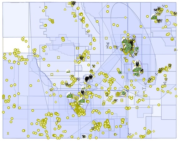 |
Wyoming Uranium Resources Database map showing the locations of uranium mines, deposits, historic mining districts, processing facilities, and a spatial bibliography. The database consolidates decades of exploration and geologic data into a modern, interactive format to support Wyoming’s uranium industry and research.
Geologic Map Modernization
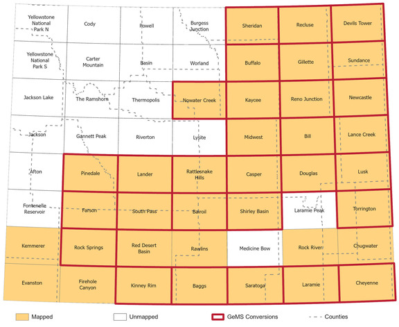
Map of 1:100,000-scale bedrock maps in Wyoming showing completed GeMS Conversions
Finally, we completed a statewide data modernization initiative converting 30 legacy 1:100,000-scale bedrock geologic maps into the standardized Geologic Map Schema (GeMS). Covering key provinces such as the Bighorn, Wind River, and Powder River basins, along with multiple Laramide uplifts, these maps are among the most heavily used geologic products in Wyoming. Standardizing them in GeMS improves consistency across datasets, eliminates formatting barriers, and makes the information more useful in GIS. Funded in part by the USGS National Cooperative Geologic Mapping Program, this project brings half of Wyoming’s 1:100,000-scale mapping into a modern, seamless format, and represents a major step toward a comprehensive digital geologic database for the state.
Together, these projects—airborne geophysical surveys, new subsurface modeling, uranium data preservation, and digital map modernization—illustrate the breadth of work underway at the WSGS. From flying surveys hundreds of feet above Wyoming’s rugged terrain to digitizing decades-old reports, our scientists are advancing the science that underpins resource development, hazard evaluation, water studies, and land management across the state. To download individual map packages, please visit the WSGS website's publications page.
|