Email
Look West: Trump's border wall threatens critical wildlife migration corridors
| From | Center for Western Priorities <[email protected]> |
| Subject | Look West: Trump's border wall threatens critical wildlife migration corridors |
| Date | May 20, 2025 1:39 PM |
Links have been removed from this email. Learn more in the FAQ.
Links have been removed from this email. Learn more in the FAQ.
Look West: Public lands and energy news from the Center for Western Priorities
** Trump's border wall threatens critical wildlife migration corridors
------------------------------------------------------------
Tuesday, May 20, 2025
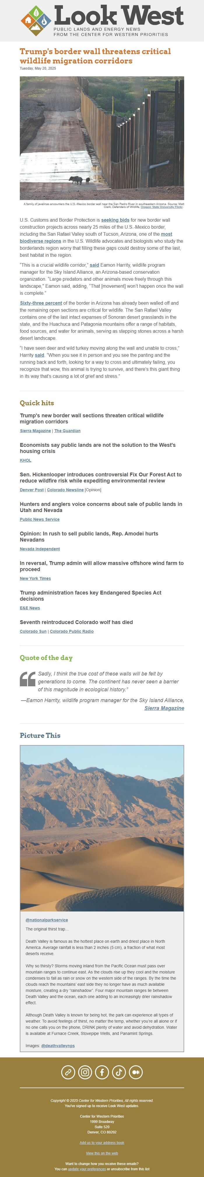
A family of javelinas encounters the U.S.-Mexico border wall near the San Pedro River in southeastern Arizona. Source: Matt Clark, Defenders of Wildlife, Oregon State University Flickr ([link removed]) .
U.S. Customs and Border Protection is seeking bids ([link removed]) for new border wall construction projects across nearly 25 miles of the U.S.-Mexico border, including the San Rafael Valley south of Tucson, Arizona, one of the most biodiverse regions ([link removed]) in the U.S. Wildlife advocates and biologists who study the borderlands region worry that filling these gaps could destroy some of the last, best habitat in the region.
“This is a crucial wildlife corridor,” said ([link removed]) Eamon Harrity, wildlife program manager for the Sky Island Alliance, an Arizona-based conservation organization. “Large predators and other animals move freely through this landscape," Eamon said, adding, “That [movement] won’t happen once the wall is complete.”
Sixty-three percent ([link removed]) of the border in Arizona has already been walled off and the remaining open sections are critical for wildlife. The San Rafael Valley contains one of the last intact expanses of Sonoran desert grasslands in the state, and the Huachuca and Patagonia mountains offer a range of habitats, food sources, and water for animals, serving as stepping stones across a harsh desert landscape.
“I have seen deer and wild turkey moving along the wall and unable to cross,” Harrity said ([link removed]) . “When you see it in person and you see the panting and the running back and forth, looking for a way to cross and ultimately failing, you recognize that wow, this animal is trying to survive, and there’s this giant thing in its way that’s causing a lot of grief and stress.”
** Quick hits
------------------------------------------------------------
Trump's new border wall sections threaten critical wildlife migration corridors
Sierra Magazine ([link removed]) | The Guardian ([link removed])
Economists say public lands are not the solution to the West's housing crisis
KHOL ([link removed])
Sen. Hickenlooper introduces controversial Fix Our Forest Act to reduce wildfire risk while expediting environmental review
Denver Post ([link removed]) | Colorado Newsline ([link removed]) [Opinion]
Hunters and anglers voice concerns about sale of public lands in Utah and Nevada
Public News Service ([link removed])
Opinion: In rush to sell public lands, Rep. Amodei hurts Nevadans
Nevada Independent ([link removed])
In reversal, Trump admin will allow massive offshore wind farm to proceed
New York Times ([link removed])
Trump administration faces key Endangered Species Act decisions
E&E News ([link removed])
Seventh reintroduced Colorado wolf has died
Colorado Sun ([link removed]) | Colorado Public Radio ([link removed])
** Quote of the day
------------------------------------------------------------
” Sadly, I think the true cost of these walls will be felt by generations to come. The continent has never seen a barrier of this magnitude in ecological history.”
—Eamon Harrity, wildlife program manager for the Sky Island Alliance, Sierra Magazine ([link removed])
** Picture This
------------------------------------------------------------
@nationalparkservice ([link removed])
The original thirst trap…
Death Valley is famous as the hottest place on earth and driest place in North America. Average rainfall is less than 2 inches (5 cm), a fraction of what most deserts receive.
Why so thirsty? Storms moving inland from the Pacific Ocean must pass over mountain ranges to continue east. As the clouds rise up they cool and the moisture condenses to fall as rain or snow on the western side of the ranges. By the time the clouds reach the mountains’ east side they no longer have as much available moisture, creating a dry “rainshadow”. Four major mountain ranges lie between Death Valley and the ocean, each one adding to an increasingly drier rainshadow effect.
Although Death Valley is known for being hot, the park can experience all types of weather. To avoid feelings of thirst, no matter the temp, whether you’re all alone or if no one calls you on the phone, DRINK plenty of water and avoid dehydration. Water is available at Furnace Creek, Stovepipe Wells, and Panamint Springs.
Images: @deathvalleynps ([link removed])
============================================================
** Website ([link removed])
** Instagram ([link removed])
** Facebook ([link removed])
** TikTok ([link removed])
** Medium ([link removed])
Copyright © 2025 Center for Western Priorities, All rights reserved.
You've signed up to receive Look West updates.
Center for Western Priorities
1999 Broadway
Suite 520
Denver, CO 80202
USA
** View this on the web ([link removed])
Want to change how you receive these emails?
You can ** update your preferences ([link removed])
or ** unsubscribe from this list ([link removed])
** Trump's border wall threatens critical wildlife migration corridors
------------------------------------------------------------
Tuesday, May 20, 2025
A family of javelinas encounters the U.S.-Mexico border wall near the San Pedro River in southeastern Arizona. Source: Matt Clark, Defenders of Wildlife, Oregon State University Flickr ([link removed]) .
U.S. Customs and Border Protection is seeking bids ([link removed]) for new border wall construction projects across nearly 25 miles of the U.S.-Mexico border, including the San Rafael Valley south of Tucson, Arizona, one of the most biodiverse regions ([link removed]) in the U.S. Wildlife advocates and biologists who study the borderlands region worry that filling these gaps could destroy some of the last, best habitat in the region.
“This is a crucial wildlife corridor,” said ([link removed]) Eamon Harrity, wildlife program manager for the Sky Island Alliance, an Arizona-based conservation organization. “Large predators and other animals move freely through this landscape," Eamon said, adding, “That [movement] won’t happen once the wall is complete.”
Sixty-three percent ([link removed]) of the border in Arizona has already been walled off and the remaining open sections are critical for wildlife. The San Rafael Valley contains one of the last intact expanses of Sonoran desert grasslands in the state, and the Huachuca and Patagonia mountains offer a range of habitats, food sources, and water for animals, serving as stepping stones across a harsh desert landscape.
“I have seen deer and wild turkey moving along the wall and unable to cross,” Harrity said ([link removed]) . “When you see it in person and you see the panting and the running back and forth, looking for a way to cross and ultimately failing, you recognize that wow, this animal is trying to survive, and there’s this giant thing in its way that’s causing a lot of grief and stress.”
** Quick hits
------------------------------------------------------------
Trump's new border wall sections threaten critical wildlife migration corridors
Sierra Magazine ([link removed]) | The Guardian ([link removed])
Economists say public lands are not the solution to the West's housing crisis
KHOL ([link removed])
Sen. Hickenlooper introduces controversial Fix Our Forest Act to reduce wildfire risk while expediting environmental review
Denver Post ([link removed]) | Colorado Newsline ([link removed]) [Opinion]
Hunters and anglers voice concerns about sale of public lands in Utah and Nevada
Public News Service ([link removed])
Opinion: In rush to sell public lands, Rep. Amodei hurts Nevadans
Nevada Independent ([link removed])
In reversal, Trump admin will allow massive offshore wind farm to proceed
New York Times ([link removed])
Trump administration faces key Endangered Species Act decisions
E&E News ([link removed])
Seventh reintroduced Colorado wolf has died
Colorado Sun ([link removed]) | Colorado Public Radio ([link removed])
** Quote of the day
------------------------------------------------------------
” Sadly, I think the true cost of these walls will be felt by generations to come. The continent has never seen a barrier of this magnitude in ecological history.”
—Eamon Harrity, wildlife program manager for the Sky Island Alliance, Sierra Magazine ([link removed])
** Picture This
------------------------------------------------------------
@nationalparkservice ([link removed])
The original thirst trap…
Death Valley is famous as the hottest place on earth and driest place in North America. Average rainfall is less than 2 inches (5 cm), a fraction of what most deserts receive.
Why so thirsty? Storms moving inland from the Pacific Ocean must pass over mountain ranges to continue east. As the clouds rise up they cool and the moisture condenses to fall as rain or snow on the western side of the ranges. By the time the clouds reach the mountains’ east side they no longer have as much available moisture, creating a dry “rainshadow”. Four major mountain ranges lie between Death Valley and the ocean, each one adding to an increasingly drier rainshadow effect.
Although Death Valley is known for being hot, the park can experience all types of weather. To avoid feelings of thirst, no matter the temp, whether you’re all alone or if no one calls you on the phone, DRINK plenty of water and avoid dehydration. Water is available at Furnace Creek, Stovepipe Wells, and Panamint Springs.
Images: @deathvalleynps ([link removed])
============================================================
** Website ([link removed])
** Instagram ([link removed])
** Facebook ([link removed])
** TikTok ([link removed])
** Medium ([link removed])
Copyright © 2025 Center for Western Priorities, All rights reserved.
You've signed up to receive Look West updates.
Center for Western Priorities
1999 Broadway
Suite 520
Denver, CO 80202
USA
** View this on the web ([link removed])
Want to change how you receive these emails?
You can ** update your preferences ([link removed])
or ** unsubscribe from this list ([link removed])
Message Analysis
- Sender: Center for Western Priorities
- Political Party: n/a
- Country: United States
- State/Locality: n/a
- Office: n/a
-
Email Providers:
- MailChimp